SAVING COQUILLE POINT: A
YEAR OF CITIZEN ACTION IN BANDON
By
Vivian Connolly
“Special places don’t
stay special by accident.”-–Jay McLoughlin, forest activist in Glenwood,
Washington.1
In the late 1980s,the small
ocean-side city of
Today
it is one of Bandon’s principal tourist attractions, especially during the
summer. Its official name is the Coquille Point Unit of the
In
the late 1980s, the Point was a desolate wasteland, its topsoil and hard-pan
layers eroded by wind, rain, tire-tracks and boot-heels into an orangey-clay
desert. Most long-time Bandonites, who
had traditionally built their homes inland, out of the reach of the punishing
coastal storms, regarded it as ownerless no-mans-land of little value.2
But
city manager Ben McMakin saw it from a different perspective. His ten years of doing the city’s business
had made him aware that Bandon was going through a time of transition. As the
local fishing, dairy, and lumber industries declined, sending young working
people to other areas, a new wave of residents had poured into Bandon, many of
them refugees from the overdeveloped seacoast of
At a city council meeting on
To the basic trio of roads, parks, and sewers,
McMakin added a special inducement: a municipal swimming pool, situated in back
of the high school, open to the general public.
The capital costs would be paid via the special financial arrangements
of Urban Renewal; the costs of operation would come from a different windfall:
the rent on a small patch of city land which formed part of the private-public
mosaic that covered the tops and sides of the rugged headland.
McMakin
had tailored his plan to appeal to the long term Bandon residents whose
memories stretched back to the days of the dance hall and the “natatorium”--a
heated salt-water swimming pool—that had made the Point a recreational center
back in the twenties. Those buildings
had disappeared, along with most of the town, in the catastrophic fire of 1936.
Efforts to resurrect the old swimming pool had foundered for lack of
money. Now the land surrounding its
ruined foundation was being eyed as the site of a new kind of buildings: high
density condominiums, intended for summer rentals; destination resorts, housing
their own entertainment complex. As the
developers turned worthless wasteland into luxury housing, perhaps the city’s
piece of the headland, small but strategically placed, could be leveraged into
a new “natatorium.”5
But
as McMakin himself acknowledged, there were many people in Bandon, who were not
so development—friendly, Bird-watchers Max and Mary Powers, savoring their
welcome withdrawal from the hurly-burly of the San Francisco bay area to a
small blue house on the blufftop, a few blocks north of the disputed area,
worried about what a sudden eruption of newly built houses might do to the
off-shore nesting grounds of Bandon’s pelagic cormorants and common murres.6 Bill and Joan Russell, returning to their
native Oregon after an international odyssey involving Bill’s career as an
officer in the U.S. Air Force and a second career in the burgeoning aerospace
industry, feared more development might drive the harbor seals from their
pupping areas on Elephant Rock.7 Owen and Sara Duvall, frequent
visitors from Klamath Falls during the 70s and 80s, who had just achieved their
long sought goal of an ocean-view retirement aerie on Beach Loop Drive, had
similar qualms about the ”seals and birds on the rocks who can’t go to the city
council and express their opinions.”8 Douglas Haines, in his
family’s bed-and-breakfast at the northwestern edge of the property under
discussion, was concerned about Bandon becoming like “so many other coast towns
where high-rise condos and hotels tower above the beaches.”9
They found an eloquent spokesman in Stan
LeGore, the co-proprietor of a struggling landscaping business. He and his
wife, Liza Ehle, had been keeping a watchful eye on the push toward beachfront
development through much of the eighties.10 Now, through an op-ed
piece in the Western World, LeGore sent out a call for grassroots
mobilization; instead of using the small city-owned plot as a bargaining chip
in the high-stakes game of Urban Renewal, the city should turn it into a public
park—“the most beautiful and spectacular park along the whole Oregon Coast.” He
invited any readers “willing to dedicate a small part of [their] lives in 1989
to political change” to contact him via the appended phone and post office box
numbers.11
In
the last three weeks before Christmas, the Western World encouraged a
lively debate on its op-ed page, featuring framed “Viewpoint” columns from
LeGore and McMakin. The reading public’s responses flowed in through the first
couple months of 1989, supporting both sides of the development question.12
By the beginning of February, LeGore felt confident of
enough support to announce the birth of the Coquille Point Newsletter. During the next two years, its
more-or-less monthly issues would serve as the organizational core of the
pro-park forces.13 LeGore used his chatty, conversational style to
prod his supporters to action, providing insistent WHAT YOU CAN DO lists: sign
the petition, come to the vital meeting, show up at the wildlife lecture, write
to the papers, contact your legislator, come help us draft the statement, make
copies, send out mailings, send money for paper and postage. Amid all the nuts-and-bolts details, he never
lost sight of his two overriding missions:
to educate his readers on the relevant issues; to convince them of what
was at stake in the current struggle. If the developers won, he told them,
there
will be a view, but it won’t be the same.
There won’t really be any open space to walk the dog, or the wife, or
your troubles, or just walk along the cliff and look at the ocean and rocks
without buildings closing in all around you.
Bandon is changing fast, and we can’t stop the changes. One of the wonderful changes is that people
are working to save the one place that can always remind us why we are here, no
matter how the rest of the town develops.14
In
his initial call to political action, LeGore had targeted Ben McMakin as the
chief obstacle to the public enjoyment of Coquille Point’s natural beauty. Now
he focused his readers’ attention on McMakin’s contract with the city
council. Many of them joined him in a
campaign against its renewal, involving street demonstrations in front of city
hall, a well-attended public meeting in
There was better news in another phase of
the battle. By May 24, Bunny Kadeau, a
volunteer wildlife docent, had organized the collection of twice the number of
needed signatures to place a proposed charter amendment on the ballot, mandating
voter approval before any of the city’s land on the Point was sold, leased, or
otherwise removed from public use.17
Now the team of LeGore and Ehle
switched its focus to Bandon’s Planning Commission. With the passage in 1973 of
Ehle’s
interest in urban planning had started in
LeGore, who had arrived in Bandon
about seven years earlier, seems to have picked up Ehle’s interest in citizen
involvement by osmosis, first as her employee and later as business partner and
husband. During an earlier anti-McMakin
campaign involving a city-built stairway down to the beach, he’d joined her in
kibitzing from the sidelines at public meetings, and shared her elation at having
their position endorsed by the planning commission, (a decision later reversed
by the city council.)
Now,
caught up in her apprehension that commercial developers were “going to wreck
one of the jewels of Bandon,” he followed Ehle’s cardinal rule, Do the
research, and started poring through the ninety-some pages of Bandon’s
Comprehensive Plan, which was kept on an open shelf in the local library. He
came up with a startling discovery: most of the land on Coquille Point wasn’t
included.
As
the result of a series of questions to city officials, he learned that when the
original Comp Plan was being written, four strategically placed parcels were
still under
LeGore immediately drafted a letter
to the Planning Commission, pointing out the land’s lack of zoning, and giving
his list of suggestions about how to correct it. A similar letter to the Western
World brought the new information to a wider public, backed up by an
editorial comment endorsing the need to look at the lands pre-annexation
status, including any restraints on building imposed by the County.21
The Planning Commission scheduled a
special session on June 15th to discuss some of the questions raised
by the gaps in the zoning. Of the
twenty-five people who signed the visitor’s list for the meeting, thirteen were
identifiable “Stannites”—as the pro-park enthusiasts were called by their
opponents.
Larry Ward, the city’s official
planner, opened the meeting, handing out detailed maps showing the boundaries
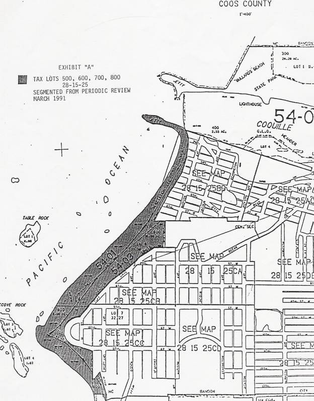
of Tax Lots 500, 600, 700, and 800. (See Map 1, p.12.) McMakin’s Urban Renewal plans had included only
the latter two items—the unzoned tax-lots which contained the land on the top
and sides of the bluff owned by the Rex
Roberts/Charles Larsen
consortium; this meeting’s primary focus was Tax Lot 600, owned by David L.
Davis, a well-known local developer, who had served for the last four months as
a member of the Planning Commission. Today, pleading conflict of interest, he’d
stepped down from his official seat among his fellow commissioners in order to argue his pro-development case.
He began by assuring his listeners
that he supported their efforts “to see Coquille Point preserved for the city.”
Then he entered an urgent plea that Tax Lot 600, no part of which lay on their
treasured headland, should not be bundled in with Tax Lots 700 and 800, owned
by the Roberts/Larsen consortium, The commission should zone his land now, not
compel him to go through the long-drawn-out process that was clearly in store
for the land the park supporters had leveled their sights on.
The anti-developers weren’t in a mood to listen. Tax
Other
members of the audience, including Hugh Harrison and Stan LeGore, expressed
their anxiety in a series of questions.
They asked for a clearer statement about the background and history of
all the newly-annexed tax lots, more information about their geological
structure, an engineering assessment of the land’s suitability for building,
information from Coos County officials about the exact legal specifications
which had governed its use under their jurisdiction, a professional appraisal
of its current wildlife. Chairman Mary Schamehorn, rising to close the
meeting,
accepted the need for more information before the commission could make any
zoning decisions on
Meanwhile, the man whom LeGore had cast as the
villain of his civic melodrama had invited a new set of voices into the
dialogue. In January, when McMakin had launched his Urban Renewal plan, he had
proposed the formation of a group of representative citizens which would make
an in-depth study of the issues involved in the fate of the Point, and give the
city council its recommendations.
When
the Coquille Point Study Committee held its first meeting in April, it became
evident, even to McMakin’s opponents, that his appointees represented a wide
range of viewpoints. There was a delegate from the Chamber of Commerce, a
realtor representing the principal landowners’ interests, a member of the
Bandon school board: there was also a strong pro-park contingent which included
Bunny Kadeau and Jordan Utsey, two of LeGore’s most active volunteers. The
members who turned out to be the most influential were two professional wildlife
experts, Mike Graybill, the director of the South Slough National Estuarine
Reserve in nearby
In
giving the committee its mandate, McMakin had focused on Goal Five of the
statewide planning guidelines, which prescribed special consideration for
The pro-park forces
had long been aware that the offshore
seastacks off Coquille Point served as resting or breeding grounds for a large
number of widely assorted sea birds. Now Sekora’s meticulous statistics backed
up that awareness with nuts-and-bolts concreteness: “On Elephant Rock,
ninety-six pelagic cormorants, four oystercatchers, 160 western gulls,
twenty-five pigeon guillemots and four tufted puffins. On the North Coquille Point Rock, 214 Brandt’s
cormorants, nearly 6,200 common murres….”24
But, as McMakin was quick to point out, it wasn’t the rocks
they were talking about. They were already protected. Now some important
decisions had to be made about the land on the headland. McMakin and Mayor Jim Cawdrey weren’t
impressed by Sekora’s attempt to expand the definition of “habitat” to include
land the birds might visit for food or fly over in their yearly migrations.
They wanted something more scientific, articles in impressive scholarly
journals, giving solid non-nonsense answers to the questions McMakin had set
before the committee: the specific boundary line development should not cross
to protect wildlife, studies available to prove the case for preservation,
practical measures to be prescribed for developers plans, involving exact
specifications on outdoor lighting, building height limits, setbacks and
traffic patterns.25
But as both Sekora and Greybill knew, there were very few
such studies. It was his thirteen years
of professional experience on the
Both experts harked back to a provision in the Open Space
section of Goal Five about enhancing the value to the public of abutting or
neighboring wildlife preserves. They
repeatedly described the Point as “best area for wildlife viewing on the
As McMakin kept pushing the question of setting development boundaries,
Sekora found himself in a tricky position.
Because of its role in implementing the Endangered Species Act, the U.S
Fish and Wildlife Service had become a perennial target of anti-government
indignation, especially in areas with strong economic interests in timber and
fishing. Its official policy counseled its agents to be cautious and
non-intrusive in matters concerning local land use decisions.29
On the other hand, all his personal and professional
instincts urged him toward taking a more active part in this particular
controversy. The unique qualities of the
Point itself, the current upsurge of local environmentalism, the strange glitch
in the legal process which had suddenly tossed the fate of a long stretch of
Bandon’s beachfront into the public arena—-surely he wouldn’t be doing his duty
if he simply ignored all these serendipitous factors.30
So when urged to define more sharply the boundaries of the
area which he recommended should be preserved as open space, he gradually
became more specific, finally committing himself to an eastern boundary at H
Street (a street not yet constructed, though platted on city maps) and setting
its northern limits at a line extending from the junction of Madison Avenue and
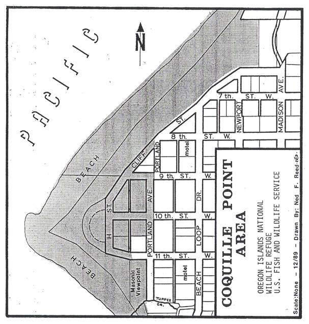
Seventh Street to three closely grouped offshore rocks.31 (See Map
2, p.13)
The
words of support from the Study Committee came at a fortunate time for the park
supporters. Two days later, on August
17, they were scheduled to meet with the planning commissioners to continue the
lively discussion about the fate of the unzoned tax lots. This time, thanks to a mandate laid down in
the land use statute, they wouldn’t be merely commenting from the sidelines;
their testimony, given from center stage, would be the main item on the
meeting’s official agenda, and though the same official decision makers would
look down on them from their high seats in the council chamber, they’d be there
in a different role: not as members of the Planning Commission, but wearing
“their second hat” as members of the Committee for Citizen Involvement.32
This
interesting structural quirk dated back to the early eighties when Bandon was
struggling to write its original Comp Plan.
The function of the Committee for Citizen Involvement, as described in
the legislation, was to insure “the opportunity for all citizens to be involved
in all phases of the planning process.”33 Faced with a shortage of
volunteers, the Planning Commission, following the example of other south coast
towns, had picked up the state-provided option of itself assuming the title of
that committee. Their chosen way of fulfilling the CCI’s rather nebulous
mission had been to hold a number of special meetings for the specific purpose
of eliciting public opinion on Comp Plan issues.34
Now, as a part of a state-prescribed
“periodic review” of the Comp Plan, they were faced with the problem of fitting
the unzoned new land into the Comp Plan.
In compliance with their original process, the commissioners had decided
to again don their CCI hats; they announced a series of public meetings,
starting on August 17, expressly designed to invite the people of Bandon into
the planning process.35
Again LeGore sent out the call in his
newsletter. The Western World reported the enthusiastic response from the
public: “Sixty-two people jammed the Council Chambers August 17 to voice their
support for leaving Coquille Point free of development.” At the chairman’s request, Palmer Sekora led
off the list of speakers, repeating what he’d been telling the Study Committee
about protecting wildlife and outlining his suggested buffer-zone boundaries.
A steady parade of pro-park speakers
followed his lead. Campaign stalwarts like Hugh Harrison, Ruben Saez and
Stephen Brown voiced their thoughts in carefully crafted phrases about the
area’s obvious uniqueness, describing the Point as Bandon’s
Mary Powers, inspired by Sekora’s
words to the Study Committee, had turned his suggested boundaries into a
tri-colored map and handed out copies to everyone in the crowd. Addressing them
from her wheelchair (a souvenir from a 1940s polio episode), she told them she
was sure there was public money available somewhere to establish a beautiful
park within those diagramed outlines.
Bill Russell, riding the wave of
enthusiasm for Powers’s vision, called for a straw vote of the crowd on the
question of protecting the bluffs.
Chairman Schamehorn asked for a show of hands; the Western World
recorded that “all but one or two” people responded.
The pro-development speakers, given their
chance to state their case at the podium, confined themselves to a few short
statements. David L. Davis had resigned
his seat on the Planning Commission in mid-July, citing conflict of interest. Now he put forward a general plea for caution
and his hope that plans for his land down by the jetty would not be caught up
in the controversy surrounding the Point.
Richard Snapp, the spokesman for the
Roberts/Larsen consortium, was new to his job, and hadn’t had time to prepare a
full presentation. His request for a two-week extension was given short shrift
by the planning commissioners. Their unanimous vote postponed any further
discussion about zoning to the next CCI meeting in mid-September.36
After the official session concluded,
City Council member Reed Gallier electrified the lingering crowd with an
unofficial proposal: that Mary Powers be appointed to head an official City
Council committee to seek out funds and support for a public park. His suggestion was approved by a unanimous
vote at the next city council meeting.37
During the following weeks, the pro-park comments in the Western
World echoed the meeting’s heady exhilaration: “People Want Bluff Protected” was the title
of Donna Leveridge’s “Viewpoint” article.38 “Bluff Message Crystal
Clear,” wrote Stan LeGore. “The vast majority of people of this community want
Coquille Point to be left open space.”39
But the group of earnest campaigners
who welcomed LeGore as their spokesman was actually only one part of
Bandon. There was another Bandon yet to
be heard from, the long-memoried residents who had lived here all of their
lives, many of them the descendants of the original settlers who had carved
their small human enclave out of an alien wilderness. Bound together by history, they resented the
current influx of “local vocals”, living on comfortable nest eggs earned in the
cities, preaching a quasi-religious duty to Nature. They considered LeGore “a terrible rabble
rouser”, Bill Russell “too energetic” and “pushy”.40 These were the people McMakin and Mayor
Jim Cawdrey felt most at home with, the people they saw as their basic
constituency, with whom they shared the political ethos common in rural areas
all over the country that valued individual property rights as the bulwark of
personal freedom. This viewpoint was
represented in
To McMakin, duty-bound to protect the city’s
precarious financial status, the exuberant outburst of pro-park feelings seems
to have loomed as an imminent threat, evoking “serious concern that the CCI
would recommend to the Planning Commission that the privately held land over
the bluff be zoned open space or natural resource” and opening up “the very
real possibility of the city being dragged into court at the cost…of thousands
of dollars.”44
So as the eager pro-park contingent
prepared more of its fervent testimony for the next CCI meeting, McMakin and
Cawdrey were pursuing a series of hasty maneuvers designed to slow down this
intemperate rush to judgment: conferences with Larsen, Snapp, and Davis;
conversations with Glen Hale of the DLCD; a quick off-the-cuff discussion with
the City Council.45
Most of the thirty-six names on the
visitors list for the CCI meeting on September 13 belonged to members of the
pro-park contingent. The first item of business on the official agenda was
“Discussion of Periodic Review, including items pertaining to Tax Lots 500,
600, 700, and 800.” They expected the meeting to follow the usual
procedure: after the formal roll call,
City Planner Larry Ward would lay out the options before the committee, and
Chairman Mary Schamehorn would ask for discussion.
But
this time it was Ben McMakin, usually a silent presence confined to the
sidelines, who took the podium, with a proposal to put the fate of Coquille
Point into the hands of a neutral mediator, a professional from the DLCD,
appointed in faraway Salem, who would assemble a task force of five to eight
people which would somehow “resolve the problem” of zoning the crucial tax lots
“without extensive and potentially costly litigation.”. He’d already obtained the informal consent of
the landowners and the city council; now he was asking the CCI/Planning
Commission to make it official.
The
questions from the audience came thick and fast. Who would be on the task force? How would its members be chosen? Would the
city be represented? Who would provide
it with input? Would the Coquille Point
Study Committee play any part in this process?
What about the land that belonged to the city? Would it enter into the mediation process?
The
answers they got from McMakin were vague and confusing. As to the task force: “It’s up to the
facilitator to figure that out… He might do it individually... maybe go to
LeGore … to Mary [Powers]… to Douglas
[Haines]… There are many ways to do it,
and he might try another way...”
There
were a couple of things about McMakin’s proposal that seemed to be reasonably
certain: it would put the zoning process on hold for from six to twelve months;
during this time the Coquille Point Study Committee would be “put on hiatus.”
When the DLCD’s liaison Gordon Hale added
some alarming comments about closed door sessions and the possibility of
binding arbitration, Commission/Committee members Fred Pryor, Mary Schamehorn
and Judy Densmore began to show some perturbation, questioning whether the
proposal for mediation might take important decisions away from the people of
Bandon.
Liza
Ehle’s tone was a bit less measured. She protested against the way the proposal
had been sprung on them out of the blue: ”Nobody in this room had any knowledge
of what was going to come before them…So when Ben says he is going to have
mediation between the two developers, instantly all the citizens say, hey what
the hell happened to us...CIAC, Citizen Involvement---we immediately got
mediated out of the picture.”
Overriding the swelling tide of
objections, the chairman invited the landowners up to the podium.
So much for the Committee for
Citizen Involvement. But how could they
move that decision on through the Planning Commission to the City Council? Should they wait for the next official
Commission meeting? Could they put on
their other hats now and become the Planning Commission? Perhaps they could forward the CCI’s verdict
to both the Planning Commission and the City Council? Densmore yanked them deftly out of the
semantic confusion: “That is a motion.
Whatever we are.”46
By the following day the mediation
proposal had already been placed on the City Council’s agenda for their
September 19 meeting. LeGore,
interviewed by the Western World’s reporter, acknowledged what seemed
like a crushing setback: “We are the victims of the arrogance of brute
force. A decision was made in a
smoke-filled room, and there was nothing we could do about it. The process failed us.”47
But the council meeting the
following Tuesday brought with it a stunning reversal. The pro-park forces, sandbagged by
McMakin’s backstage maneuverings, had
decided it was time to hire their own lawyer.
Acting at their behest,
The letter arrived at City Hall on
the morning of September 19th.
The city council meeting started that evening at seven, with lawyer
Lesan in attendance to back up his written comments. Myron Spady, the city attorney, forestalled
any discussion of mediation, admitting the “good possibility” that the city had
made a “procedural error” The council members heeded their legal advisor’s
advice to avoid a “procedural wrangle” by postponing any further discussion on
the CCI’s recommendation until October 3rd, at which time a
unanimous vote of the council sent it back to the CCI, where it never received
any further serious attention.48
The pro-park enthusiasts
had fought a successful defensive action, putting the question of zoning the
beachfront back where LeGore thought it belonged, in the hands of the Planning
Commission. But the Commission wasn’t
yet ready to tackle this hot potato.
They decided to detach the troublesome tax lots from the mass of other
loose ends they were tidying up in the Periodical Review of the Comp Plan by
isolating them under yet another DLCD label: “Segmental Review”; thereby
pushing the zoning decision far into a highly indefinite future.49
Meanwhile, Mary Powers had recruited her
own hard-working committee, including two members of the city council, Lee
Sutton and Milan Brace. Their first
contact outside the local power structure, Congressman Peter DeFazio, had
helped them expand their burgeoning network to include Senators Robert Packwood
and Mark Hatfield. Powers had been using her remarkable powers of persuasion to
enlist the support of some national environmental organizations—The Nature
Conservancy, Defenders of Wildlife, The Trust for Public Lands—with the 1000
Friends of Oregon providing consultative backup.50
The September 27 issue of the Western
World carried a photo of Powers touring the Point with the regional state
parks supervisor, Ron Hjort “to see what
shape a park on the point would take.”
By the end of October, she was telling the council that the state park
department’s office in
As the idea of a park in Bandon
gathered momentum in
The meeting was held in the
glass-fronted second-floor dining room of Lord Bennett’s restaurant, a few
blocks south of the Point. The state’s plan for the park as laid out by
landscape architect Kathy Schutt-Staver, embraced all of the land within
Sekora’s suggested boundaries, and proposed a cooperative venture between the
state and the city. The state would
provide $300,000 to build and maintain the park’s basic amenities: a parking
lot, landscape planting, an interpretive structure, trails and fencing, a
viewing site, public toilets. The cost of acquiring the land—-which might run
as high as $1.4 million--would be equally shared by the state and the city.54
For the pro-park activists, the
state’s proposal represented a high point in their campaign to keep this unique
stretch of Oregon coastline in the hands of the general public.55
They had come a long way during this turbulent year. LeGore’s early vision of saving a few cramped
acres had grown to include the whole of the rocky headland, plus an additional
swathe stretching northward to the site of the Table Rock Motel, at the corner
of
There was still a rough road ahead. The state, having made its first offer, was
expecting the city to come through with a pledge of commitment, backed up by
some definite action: putting a ballot measure before its voters to finance a
bond issue; finding a way to freeze any private development while they waited
for public funds to make their tortuous way through the pipeline.56
McMakin’s experience had made him
acutely aware of all the things that could go wrong between the state
government’s promise and the time the funds made it down to the local
level. His first chance to get a bond
measure onto the ballot was on March 27, four months away. And what if the voters decided against it?
Any measure which threatened to raise property taxes was bound to meet with a
good deal of opposition.
Nevertheless when he laid the state park
proposal before the council on the night of December 5, McMakin threw the
considerable weight of his personal influence squarely behind the proposed
state park, recommending that the requisite bond issue should be placed on the
March 27 ballot and that a building moratorium should be imposed on all the
land within the proposed state park area.
After
about an hour of public discussion, the moratorium question was put to the
council: members Watson, Martindale, and
Sutherland, previously its staunch opponents, joined the pro-moratorium faction
of Sutton, Tiffany, and Gallier in a unanimous vote for an emergency moratorium
of thirty-five days, and set the date of December 19 for an official hearing
about extending the freeze for a further four months.57
On
that very same night, while the Bandon Council was giving the state park
proposal its stamp of approval, a small group in the
Government
protocol required Sekora to wait until December 12 before sending the official
proposal to the city manager. His first
public presentation, to a crowd of more than a hundred people who piled into
City Hall on the night of December 19, came at the start of the officially
scheduled moratorium hearing.59
He
quickly sketched out the new plan’s essentials:
The United States Fish and Wildlife Service was proposing full federal
funding for the acquisition, rehabilitation and development of Coquille Point
as part of the Bandon National Wildlife Refuge.60 The park boundaries would be essentially the
same as those in the state park plan; the same basic amenities would be
provided. The state park department
would probably handle the maintenance duties.
His agency was assured that the project’s supporters in Congress would
include the funding for the new refuge in the 1991 federal budget. The Nature Conservancy had agreed to serve as
a financial bridge during the acquisition process, which would involve only
willing sellers at fair-market prices. From what he could see at this point,
this could all be done at no cost to the city.60 As LeGore summed
things up in his exuberant newsletter, “Essentially the council was presented
with a two million dollar development proposal with no strings attached.”61
There was still a long journey
ahead, replete with acrimonious court fights, stormy public debates, and
excruciatingly slow bureaucratic procedures before the refuge was made
official. From this point on, most of
the crucial decisions would be made far from Bandon—-in
Map1: Source—
Map
2--Source:
NOTES
1. Quoted in William G. Robbins, “The Place
We Call Home, “
2. Liza Ehle,
interview by author,
3. For a vivid
account of the abrupt decline of the southwest coast’s timber industry during
the 1980s, see William G. Robbins, Hard Times in Paradise, Coos Bay, Oregon,
Rev. ed. (Seattle: University of Washington Press, 2006). For new
residents/real estate prices, see editorial, Western World (Bandon),
4. Ben McMakin,
“Viewpoint,” Western World,
5.”Manager Floats
Idea for Bluff, Airport Development,” Western World,
6. Max Powers,
phone interview by author,
7.Bill and Joan
Russell, interview by author, Bandon,
8. Sara Duvall,
interview by author, Bandon,
9. Douglas
Haines, letter to the editor, Western World,
10. Liza Ehle,
“Viewpoint.” Western World,
11. Stan LeGore,
“Viewpoint,” Western World, December 1988. LeGore follows the Western
World article (note 5) in describing the city plot’s area as 3.8 acres; in
a later statement, McMakin reduced this figure to 1.91 acres. (Ben McMakin,
“Viewpoint,” Western World,
December 14,1988).
12. Stan LeGore, “Public Good Vs. Private
Gain,” and Ben McMakin, ””Growth Helps Ease Tax Load,”Western World,
December 14, 1988; Susan Snyder, letter to the editor, Western World,
February 1, 1989; Jane Reed, letter to the editor, Western World,
February 8, 1989.
13. Stan LeGore, “Viewpoint,” Western
World,
14. Coquille Point Newsletter,
15. Lee Sutton, “Viewpoint,” Western
World, February 22, 1989; “Protesters Boycott Council Input Session,” Western
World, April 12, 1989; “Concerns Aired at Town Hall,” Western World,
April 26, 1989; Catherine Haines, letter to the editor, Western World,
March 15, 1989; Lenny Worth, letter to the editor, Western World, 1989;
Ray Steinbroner, letter to the editor, Western World, 1989.
16. “Council Votes 5-1 to Retain City
Manager,” Western World,
17. “Coquille Point Initiative Petitions
Being Verified,” Western World,
18. Mitch Rohse, Land-use Planning in
19. Ehle, interview.
20. Coquille Point Newsletter,
21.
Stan LeGore, letter to the editor; “Comment: Focusing on Growth,” Western
World,
22. Meeting narrative:
”Beach Bluff Lands and Development: Planners Want to Know Before Zoning
Parcels,” Western World, June 21, 1989; Bandon Planning Commission
Minutes, June 15, 1989; Max Powers, taped interview based on author’s
questions, Oakland CA, July 2007; “Comment: Moving Wisely,” Western World,
June 21, 1989; Bob and Joan Steele, letter to the editor, Western World,
May 31, 1989.
23. Bandon City Council
Minutes,
24. (Bandon) Coquille Point Study
Committee Minutes,
25. Ibid; see also ”Wildlife Experts
to Talk with Point Committee, Western World,
26. Coquille Point Study Committee
Minutes,
27. “Subcommittee Learns of Wildlife
Needs,” Western World,
28. Dirk Vinlove, “Coquille Point
Called ‘One of the Best Wildlife Viewing Areas in Nation,’” Western World,
29. Russell, interview.
30. Palmer Sekora, e-mail
message to author,
31. “
32. “Wildlife Experts to Talk with
Point Committee, ”Western World,
33. Rohse, 256.
34. Bandon Planning
Commission Minutes,
35. Bandon Planning
Commission Minutes,
36.
Meeting narrative: Western World,
37. Bandon City Council
Minutes,
38.
39.
40. Barbara Eakley,
interview by author, Bandon,
41. Rohse, 221.
42. Jim Davis, letter to
the editor, Western World,
43. Bandon Committee for
Citizen Involvement Minutes,
44. Jim Cawdrey,
“Viewpoint,” Western World,
45.
Bandon Committee for Citizen Involvement Minutes, September 13, 1989; Bandon
City Council Minutes, September 19, 1989; “Bluff Mediator Idea to Be Aired,” Western
World, September 27, 1989.
46.
Meeting narrative: Bandon Committee for Citizen Involvement Minutes,
47. McMakin and LeGore quotes, “Mediator to Be Asked for Bluff
Solutions,” Western World,
48. Bandon City Council Minutes, September 19 and
49. Dirk Vinlove, “Bluff Lands Singled Out for Closer Review,” Western
World,
50. “Senators,” Bandon City Council Minutes, September
19, 1989; “national organizations,” Powers, “Viewpoint”; “Friends,” Stan
LeGore, letter to Bandon Committee for Citizen Involvement, September 16 1989 (Bill
Russell collection).
51. Bandon City Council
Minutes,
52. “Voters Say ‘Retain Voice at Coquille Point,’” Western
World,
53. Bandon City Council Minutes,
54. “City Bond Asked to
55. Mary Powers, Douglas Haines, Stan LeGore, and Eric Armstrong
were identified by the Western World (November 29, 1989) as “citizen
representatives” at this meeting.
56. “Freeze private development,” Bandon City Council Minutes,
57. Bandon City Council Minutes,
58. Melody Gillard-Juarez, “Federal Funds Said Likely for Park
at Coquille Point,”
59. Dirk Vinlove, “
60. The proposal was later amended to place the Coquille Point
site into the Oregon Islands National Wildlife Refuge.
61. Bandon City Council Minutes,
62. Coquille Point Newsletter,